


les mees

Clo0413
User
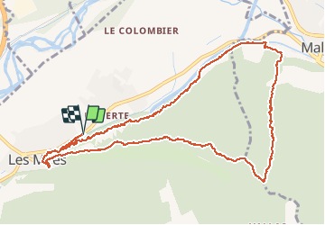

Length
13.3 km

Max alt
779 m

Uphill gradient
522 m
Km-Effort
20 km

Min alt
408 m

Downhill gradient
522 m
Boucle
Yes
Creation date :
2021-02-08 08:04:27.42
Updated on :
2021-02-08 13:29:08.772
5h23
Difficulty : Very easy

FREE GPS app for hiking
 SityTrail
IGN / Geographical institutes
SityTrail Plus
The world is yours!
About
Trail Walking of 13.3 km to be discovered at Provence-Alpes-Côte d'Azur, Alpes-de-Haute-Provence, Les Mées. This trail is proposed by Clo0413.
Positioning
Country:
France
Region :
Provence-Alpes-Côte d'Azur
Department/Province :
Alpes-de-Haute-Provence
Municipality :
Les Mées
Location:
Unknown
Start:(Dec)
Start:(UTM)
739235 ; 4879853 (31T) N.
Comments